Whether you like hanging by the creek, hiking in the woods or up a mountain, or finding that sweet little hole-in-the-wall bar or restaurant, there are lots of things to do near us.
Restaurants

Dave’s 209
A great little burger place not too far from Mountain Fiesta. You’ll find lots to like about Dave’s.
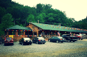
Trust General Store
A great place for a bite to eat. You can also find gas, fishing licenses, bait and tackle, and convenience store items just two miles from Mountain Fiesta.
Spa

Hot Springs Resort and Spa
Call ahead to book a natural mineral bath, body treatment, hot stone, or Swedish massage. One of the most unique “spas” in the US and the only natural mineral baths in NC. The resort has numerous private hot tubs available for soaking by the hour.
Mountain Biking

Bluff Mountain Outfitters
Located on the Appalachian Trail in the town of Hot Springs, they specialize in helping through-hikers get the right gear to finish their trip. A good selection of whatever you might need plus some friendly conversation, a fax machine, and internet access. They also offer shuttle service for hikers, rafters, and bikers.
Horseback Riding/Llama Trekking
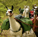
English Mountain Llama Treks
Offers single and multi-day treks in the Pisgah and Nantahala National Forest of North Carolina as well as the Dupont State Forest.

Sandy Bottom Trail Rides
Located on secluded farm minutes north of Asheville, NC, these horse trails pass through the beautiful high country, scenic mountain meadows, and wooded areas of Madison County.
Golfing

Lake Junaluska Golf Club
Offers a scenic, fun, and challenging 68 par course with incredible views of Lake Junaluska and the surrounding mountains. Book a tee time for a one-time visit. The course is open to the public and welcomes families.

Maggie Valley Club and Resort
Enjoy playing golf at one of the most scenic golf courses in North Carolina. Offers fun and unique challenges for beginners and seasoned golf players, as well. Players can warm up at the front Valley Nine or take on the challenging Mountain Nine, which has an elevation rise of 800 feet and panoramas of the valley and beyond.
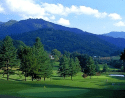
Springdale Golf Resort
Located at the base of Cold Mountain, Springdale’s championship course offers a unique and challenging test of golf that is only enhanced by its breathtaking views of the Blue Ridge Mountains. The scenic yet forgiving front nine slowly allows you to find your rhythm and gain confidence in your game.
Clay Shooting

Fowler Farms Sporting Clays
Sporting clay shooting is the newest and fastest-growing shotgun sport in the USA. It’s a great way to learn how to shoot without hurting anything.
Water Fun
Rafting
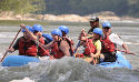
French Broad Rafting
Experience the thrill of white water rafting on the French Broad River. Offers five-mile or nine-mile whitewater rafting trips that last from 3-6 hours. You can also float down the river on guided and unguided float trips and rentals on a calmer section of the French Broad River.

Headwaters Outfitters
Offers family-friendly fishing, paddling, and tubing trips on the French Broad River for beginner and seasoned paddlers.

Hot Springs Rafting
A family-owned company dedicated to custom, personal trips, and giving you the exact river experience you’re looking for. Offers half-day and full-day guided river rafting and tubing down the French Broad River.

USA Rafting
A premier full-service adventure company offering rafting, caving trips, guided fishing, stand-up paddling, and tubing down the Nolichucky and French Broad Rivers.

Zen Tubing
Floating down the French Broad River is one of the favorite Asheville activities. Making a reservation entitles you to a super comfy tube, a life jacket, and a great time.
Swimming Holes
Off of Puncheon Camp Rd on the way from Mountain Fiesta toward Hot Springs about 15 minutes away.
Here is a Google Map of the area.
As well Rocky Bluff Campground…….on the way to Hot Springs about 20 minutes away from Mountain Fiesta.
And here is a Google Map to help you locate it.
This Campground is closed but access to Spring Creek is easy. You just park at the entrance and walk-in. A few people use it but it is virtually off the grid because you can not drive through.
Hiking
Max Patch
Directions from Mountain Fiesta: Take a right out of Mountain Fiesta onto Hwy 63 and proceed 2 miles to junction NC 209. The Trust General Store and Cafe is on the left. Take a right on NC 209. Pass the Fire Department and the Spring Creek Community Center which also houses Dave’s 209 Burgers. Take the next left at Caldwell Mountain Road. Proceed over Caldwell Mountain to the stop sign. Turn right onto Meadow Fork Rd. Follow Meadow Fork Rd. approximately 1.5 miles to Little Creek Rd. on your left; there is a sign to Max Patch. In about 300 yards, Poplar Gag (paved) goes off to the right. Bear left up Little Creek (gravel road). After 3 winding miles, Little Creek Rd. ends at a stop sign on Max Patch Rd. (gravel). Turn right and proceed approx. 1.5 miles to Max Patch Mountain. Max Patch parking area will be on your right. Max Patch Pond is just past there.
Absolutely, positively, the best hike if you only have time for one! Elevation: 4,692 feet. [Take 25/70 out of Hot Springs go 7-8 miles turn right on Meadow Fork, right on Little Creek, then a right onto Max Patch Rd . Be sure to stop at Panther Branch Rd along the way to see a lovely waterfall. Panther Branch dead-ends so head back to Meadow Fork Rd once you have seen the waterfall. Just one-half mile from the parking lot to the top and you have panoramic 360-degree views into Tennessee, The Great Smoky Mountains National Park, and even all the way to The Blue Ridge Parkway! Max Patch offers a gentle climb across the southernmost bald on the Appalachian Trail to its grassy summit at 4,629 feet. During the warmer seasons, the trail abounds with wildflowers. Max Patch was privately owned until 1982, the land covered by the trail had been used for grazing sheep and cattle. An offer to sell to a ski development was fortunately countered by the U.S. Forest Service, which bought the 392 acres for the Appalachian Trail. Take a jacket as it is often very windy and exercise caution during the winter months as the road to Max Patch may be icy and dangerous even when there is no snow at Hot Springs. The AT Trail from Max Patch can also be the starting point for an AT trail hike to the north (towards Hot Springs) or south (towards The Great Smoky Mountains National Park).
The northern segment travels 20 miles to the town of Hot Springs. The first 7 miles along this segment are easy, gaining less than 1,000 feet in elevation, but the path soon climbs steadily toward the wooded summit of Walnut Mountain (elevation 4,280 feet). After a short stretch on an old roadbed, the trail reaches Cat Pen Gap and ascends Bluff Mountain (elevation 4,686 feet). From here the trail drops steadily, losing more than 3,000 feet along its 10-mile descent into Hot Springs.
Appalachian Trail
US Forest Service (Pisgah National Forest – Appalachian Ranger District), PO Box 128, Hot Springs, NC 28743, (828) 622-3202. Appalachian Trail- There is public access to the Appalachian Trail in Hot Springs on 25/70 located behind the Catholic Church. Another public access is located at the end of Gorenflo Gap Road in the Spring Creek area, just 8 miles from Hot Springs on 209 (turn right on Gorenflo Gap Road. Gorenflo Gap Road is 1 1/2 miles long and terminates at the AT trail access point.). Bluff Mountain Outfitters operates a shuttle service for hikers. You can also get onto the AT from Rocky Bluff Campground & Hiking Trails, located halfway between Hot Springs and Spring Creek, Rocky Bluff boasts a beautiful walking trail along Spring Creek (watch for signs of beaver activity!) as well as the Vann Cliff trail.
Spring Creek Nature Trail
Accessed from Rocky Bluff Campground, 3 miles south on 209, on your left as you leave Hot Springs. The Campground is only open May -November, but you are always welcome to park your car at the gate and walk down to the trail. Easy 1.6-miles loop along Spring Creek. Lots of beavers in the area too!
Van Cliff Loop
[Also from Rocky Bluff Campground] A 2.6 miles, steep, difficult hike along streams and ridge tops where the forest has reclaimed old farmland. The Trail leaves the south end of the Rocky Bluff Campground, crosses NC 209, and ascends Taylor Hollow Creek.
AT Trail Access at Gorenflo Gap
The trailhead at Gorenflo Gap is reached via traveling south on 209 for one-half mile, then following Gorenflo Gap road for 1.5 miles to the trailhead. From here you can hike into Hot Springs or Upper Shut-In (see below).
Trails from the Silvermine Trailhead in Hot Springs:
Lovers Leap Trail 1.6 mile loop from the Silvermine Trailhead: walk down the road and get on the Appalachian Trail (white blazes) along the French Broad River. After about 0.5 miles the trail climbs steeply to Lover’s Leap ridge where rock outcrops provide great views. Return on the Lover’s Leap Trail (Blue Blazes) and descend to the trailhead.
Pump Gap Loop
2.4 miles. Follow The Lovers Leap Trail from the Silvermine trailhead. At the first major switchback, the Pump Gap Trail goes straight. At the next right fork, the trail climbs to the AT at Pump Gap, crosses then returns by a combination of old forest roads and foot trails. The Trail is Moderate in difficulty, offering many changes in elevation and scenery. Can be looped with the Appalachian Trail.
Appalachian Trail From Hot Springs to Allen Gap
14.7 miles. (white rectangle blazes) Heading north, the AT crosses the bridge over the French Broad River then jumps the guardrail to the right. The AT follows the river upstream ascends Lover’s Leap Ridge then after 5 miles come to the grassy meadows and pond of Mill Ridge. The trail then descends to Tanyard Gap where it crosses US 25/70 on an overpass, climbs to the junction of the Round Top Ridge Trail, passes the Rich Mountain Fire Tower Trail then comes to the junction of FS467a, FS422 & FS3514. Shortly after this junction, the trail comes to Hurricane Gap (FS467). The trail then continues north passing Spring Mountain Shelter and finally coming to NC208 (Allen Gap). A nice loop can be made with the Pump Gap Trail or the Round Top Ridge Trail. Another loop option begins at Tanyard Gap and returns to Tanyard via Salt Box Road (FS3514).
Roundtop Ridge Trail
3.2 miles one way from the Junction with the Appalachian Trail on Rich Mountain, the Roundtop Ridge Trail meanders down the ridge, past old farm fields and through an oak-hickory forest. The Trail ends on Reservoir Road near the Hot Springs Water Tank. Reservoir Road joins the River Road 1/4 mile downstream of US 25/70. This trail can be hiked as a loop with the AT (8.8 miles AT-3.2 Miles Roundtop Ridge-1.5 miles road).
Trails Accessed from Shut-In Road, just outside Hot Springs:
In Hot Springs stay on US 25/70 West and follow it for 3 miles, then turn left on Upper Shut-In Road (SR1183).
Betty Place Trail
1.2 miles. It is an easy loop on a magnificent north-facing slope of Bluff Mountain. The Trailhead is nearly at the end of Upper Shut-In Road on the left. The trail passes remnants of several home sites.
East Fork of Shut-in
2.0 miles one way, moderate hike along Shut-In creek from Upper Shut-In road to the Appalachian Trail at Gorenflo Gap. Arrange a shuttle ride with Bluff Mountain Outfitters.
Trails outside the town of Hot Springs accessed via River Road:[Follow River Road to Murray Branch or Paint Rock.]
Murray Branch Picnic Area
The Murray Branch Recreation Area is located 6 miles down the French Broad River from Hot Springs. The area offers recreational opportunities for picnicking, fishing, and canoe access to the river. Facilities at Murray Branch, under the shade of pines, include picnic tables, grills, restrooms, water, and two picnic shelters for large groups.
River Ridge Loop Trail
1.3-mile loop. A moderate loop that climbs through a pine forest for a bird’s-eye view of the French Broad River and the surrounding valley. The trail begins across from the Murray Branch Picnic Area.
Jack Branch Trail
2.4 miles one way, (blue blazes). A steep, difficult trail that climbs to 2900′ for good views of Hot Springs and the French Broad River. The trail begins on The River Ridge Loop crosses The Polecat Hollow Road (FS468) and ends at The Shad Road (FS422).
Paint Rock Trail
1.3 Miles, Difficult, 7 miles from Hot Springs. The trail begins at Paint Rock, 7 miles from Hot Springs via river road. Take FS 54 towards Lone Pine Gap 1/10 mile. Look for the trail on left near Forest Service road sign. The trail ascends steeply to the intersection of The Chimney Rocks Trail. There is a beautiful view of Weaver’s Bend and the north side of Bluff Mountain at this trail junction.
Trails Accessed from the junction of US 25/70 & NC 208:[Follow 25/70 East to its junction with NC 208 at The Steady Eddy Coffee Shop.]
Laurel River Trail
(3.6 miles one-way)The trail begins near the junction of NC 208 and 25/70 on a dirt road that turns into the trail. Singletrack on an old railroad grade to the ghost town of Runion where the Laurel empties into the French Broad River. Easy grade.
Shelton Laurel Backcountry
Follow 25/70, then turn left (north) on NC 208 at the Steady Eddy Coffee Shop until it intersects with NC 212, and take a right. Continue for 6.8 miles to NC 1310, which is known as Hickey Fork Road. Turn left and drive until you see the parking area on the right. The trailhead begins about 200 feet up the road, on the left.
Hickey Fork Waterfall Only
1.1 miles in length, the trail to Hickey Fork Waterfall is strenuous. The falls are rich with growing mosses. The small grottos that can be spotted behind its mist provide a habitat for the spray-cliff natural community. Hike in about 1 mile. At this point, a smaller yet beautiful cascade occurs on the right. To reach the main waterfall, continue another 1 mile. Some bushwhacking is necessary to reach the base of the waterfall. Hemlock, white pine (Pinus strobus), yellow-poplar (Liriodendron tulipifera), rhododendron (Rhododendron catawbiense and maximum), mountain laurel (Kalmia latifolia), dog-hobble (Viburnum alnifolium), and ferns are all common.
If you have any questions, feel free to let us know.